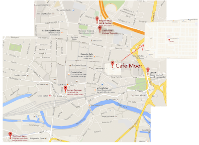
I started out my process by marking out on google maps where all the different locations where in relation to one another, I was told that the order was Belgrave > Vintage Tearoom > Cafe Moor > Cafe 164 > Cross Keys. It turned out, Laynes was at Belgrave instead of being a location on it's own.
I then collected images of all the locations exteriors for reference imagery, from google maps. As well as landmarks which may later help, such as the corn exchange.
Using this information, I created links between the locations which would be the shortest route. The hardest problem here was figuring out how to fit in the Cross keys due to it's location been so far away. Thankfully, the road doesn't contain any bends so it'd be easy to shorten down, it's just how do I balance that with the rest of the locations and do I keep them to scale?
Without laynes, this was the best route I could establish, which is slightly trickier but I believe I'll be able to work this in.


No comments:
Post a Comment